Document

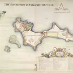
A colored "ground plott of Elizabeth Castle;" drawn in 1680, by Thomas Phillips, on a scale of 20 yards to an inch.
Accompanying this plan of Elizabeth Castle is an "accompt taken of all the ordnance, etc., in Elizabeth Castle, in his Matys. island of Jersey; likewise how and where mounted; by Capt. Richard Leake, Master Gunner of England, with his opinion what alteration or addition may be made to the same." 1 June, 1680. This map is from a larger report prepared for King Charles II in 1680-81: '"The present state of Guernsey, with a short account of Jersey and the forts belonging to the said islands, by Col. George Legge, [afterwards created Lord Dartmouth,] Lieutenant Generall of his Majesties Ordnance, anno Domini 1680." Dedicated to Charles II., Jan. 9, 1680/1; being a large folio volume, embracing the reports of Christopher Lord Hatton, Governor of Guernsey, Sir Bernard de Gomme, Capt. Richard Leake, etc., and having numerous colored plans and views by Thomas Phillips, which will be f ound described in separate entries. The title-page is in letters of gold and is richly ornamented; the royal arms are at the top, and the arms of Col. Legge at the bottom.
The British Library1680

